A Complete Manual for Conducting International Flight Operations
Gross Navigation Error Check
Gross Navigation Error Check
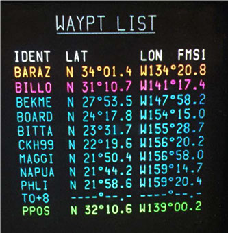
A gross navigational error check is to be performed 10 minutes after crossing a waypoint. The gross navigational error check is a method used to determine that the aircraft is established on the route that it was cleared and enables the flight crew to discover navigational discrepancies prior to a gross navigational error occurring. For ACI Jet pilots it is recommended that flight crews operate with a waypoint list presented on one of the MFD’s or EICAS screens as an additional means of situational awareness.
In the example to the right, it is very easy to determine that the aircraft is currently flying the leg between BARAZ and BILLO and is presently located at North 32.10.6 latitude, West 139.00.2 longitude. For recording a 10 minute GNE plot, the pilot simply records the PPOS 10 minutes after crossing a waypoint and plots the position on a plotting chart. The position should along the course line provided the aircraft is on course and the aircraft’s route has been plotted correctly.
JOIN THE CONVERSATION

The material contained on this site is to be used for reference only. You should always follow your primary resources first (aircraft manuals, government regulations, etc.).
Savant Aero is no way affiliated with any aircraft manufacturers.